20. Archdale Square, 1683
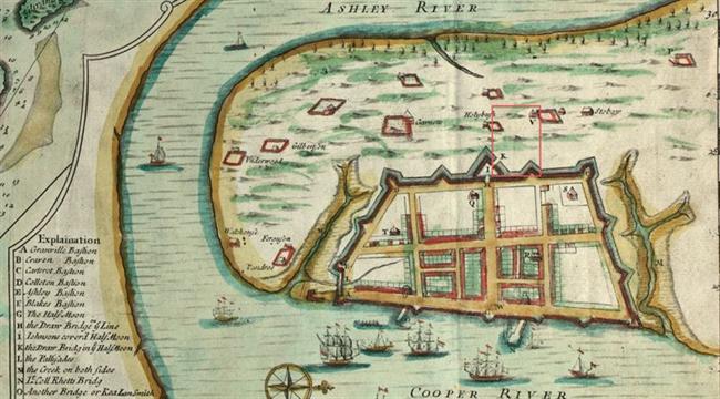 |
| Edward Crisp, “A Compleat Description of the Province of Carolina in 3 parts.” 1711. American Memory, Library of Congress http://memory.loc.gov/ |
|
Archdale Square, 1711.
|
|
“Archdale Square” was granted to Thomas Archdale, one of the Lords Proprietors. Archdale was a child, the son of John Archdale and Ann Cary; his father purchased the proprietor’s share in 1681 in trust for Thomas, and his father was trustee of the real estate.
On July 12, 1683, South Carolina’s surveyor general laid out to Thomas Archdale “one lot at Charles Towne known by the No. 107, butting northward upon a street that runneth westerly from Cooper River by the lot of Mr. Maybank and Mr. Pendarvis, and southward part upon the Great Street by the Market Place and upon the lot of Mr. Bamer and Mr. Dedcott, and eastward upon the Market Place and upon a Great Street that runneth near north and south and leadeth into the Market Place, and west upon a street that leadeth from Ashley River by the lot of Mrs. Benson and Mr. Stevens and runneth north and parallel with one of the Great Streets.”
There seems to have been little development on the lot while it was in Archdale’s possession. His father was appointed governor of Carolina in 1694, and spent about a year in Charleston (August 1695-October 1696) before returning to England. Proprietor Thomas Archdale might already have left Carolina: he was elected to Parliament in 1699, after an Oxford education.
In 1695, during John Archdale’s term as governor, William Sadler received a grant for Lot 97, in the northwest corner of Archdale Square (corner of King and Queen streets). On the lot south of Sadler, a Quaker meeting house was established sometime before the “Quaker Lot” was warranted to Mr. Thomas Kimberly in 1717.
Archdale Square has evolved through a series of residential, commercial, governmental, and institutional uses. The Quaker meeting house and burial ground, the 1753 colonial house of assembly, the (original) Mills House Hotel, the Timrod Hotel, and many other buildings have disappeared from the block. However, notable buildings remain: Hibernian Hall, South Carolina’s first state house (Charleston County Courthouse), and the Hebrew Orphan Society building. Bates, Susan Baldwin, and Harriott Cheves Leland, eds. Proprietary Records of South Carolina. Volume Three: Abstracts of the Records of the Surveyor General of The Province, Charles Towne, 1678-1698. Charleston: History Press, 2007.
“Thomas Archdale.” http://www.thepeerage.com
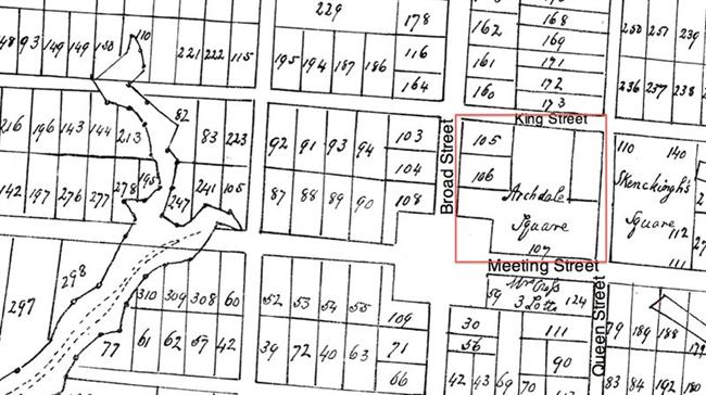 |
| Henry A. M. Smith, “A Platt of Charles Town.” South Carolina Historical Magazine, 1908 (copy in City Engineer’s Plat Book, South Carolina History Room, Charleston County Public Library) |
| Archdale’s Square fronted on today’s Meeting Street, “the Great Street by the Market Place,” Broad Street, “a Great Street that runneth near north and south,” King Street, “a street that leadeth from Ashley River,” and Queen Street, “a street that runneth westerly from Cooper River.” |
| |
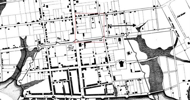 |
| Bishop Roberts and W. H. Toms, The Ichnography of Charles-Town at High Water. London, 1739. |
| Archdale Square, 1739. “F” marks the Quaker Meeting House. The town wall and gate seem to have extended into the corner lot where the colonial assembly hall would be erected. In 1999, part of the fortification wall was uncovered, eight feet below street level. |
| |
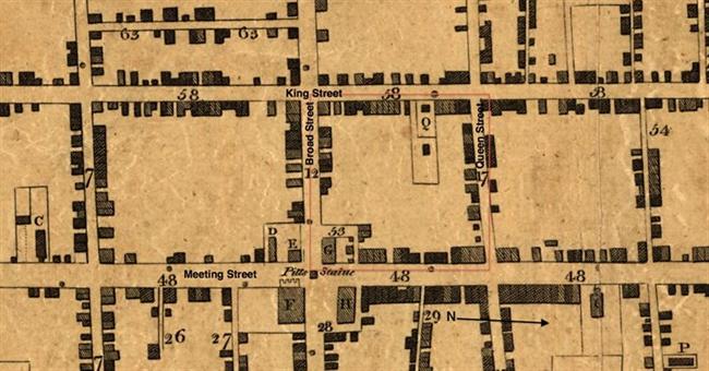 |
| Edmund Petrie, Ichnography of Charleston, South Carolina. London, Phoenix Fire Company, 1788. American Memory, Library of Congress http://memory.loc.gov/ |
| 1788 map showing State House Square (53), the building “formerly State House now Court House &c.” (G), and “Quaker Church” (Q). |
| |
 |
| Historic American Buildings Survey, Library of Congress http://memory.loc.gov |
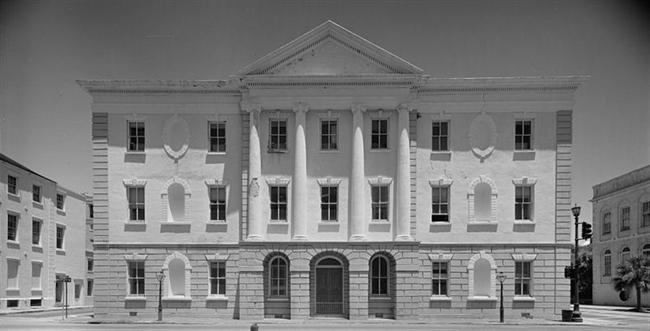
| Charleston County Courthouse, Broad Street, 1991. The colonial assembly hall and council chamber building, first used in 1756, burned in 1788. It was rebuilt as the South Carolina State House in 1792, but placed into service as the Charleston County Courthouse. The courthouse was restored after Hurricane Hugo. |
| |
 |
| Historic American Buildings Survey, Library of Congress http://memory.loc.gov |
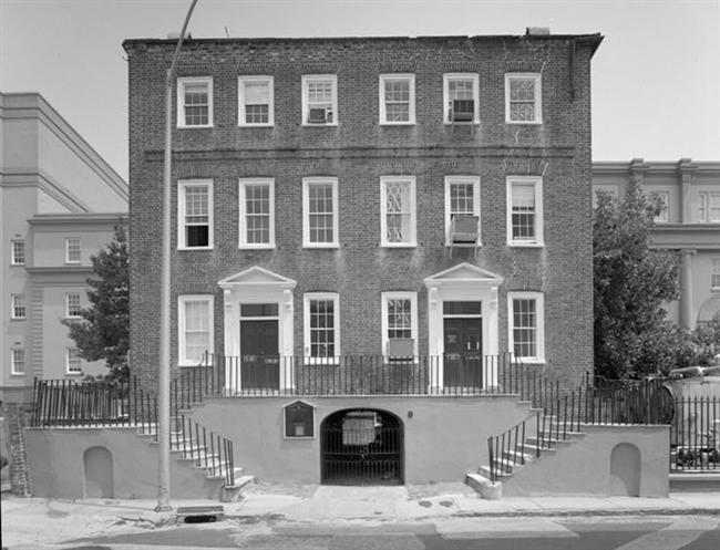
| 2-4 Courthouse Square, 1990. The Daniel Blake Tenement House was built between 1767 and 1772. |
| |
 |
| Historic American Buildings Survey, Library of Congress http://memory.loc.gov |
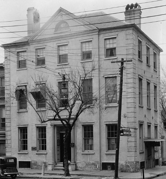
| Hebrew Orphan Society Building, 88 Broad Street, 1934. Built ca. 1800 on part of Archdale Square that was granted to Jacob Allen in 1696; housed the Bank of the United States and the Bank of South Carolina before its purchase by the Hebrew Orphan Society in 1833. |
| |
 |
| Historic American Buildings Survey, Library of Congress http://memory.loc.gov |
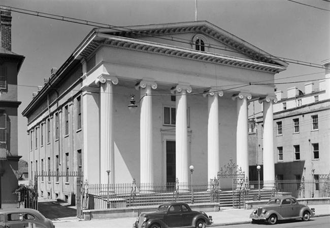
| 1940 view of Hibernian Hall (built 1839-1841), 105 Meeting Street. |
| |
 |
| The Metropolitan Museum of Art, New York http://www.metmuseum.org/Collections |
George N. Barnard, “Hibernian Hall, Charleston” ca. 1864. At right is the iron balcony of the Mills House Hotel.
|
| |
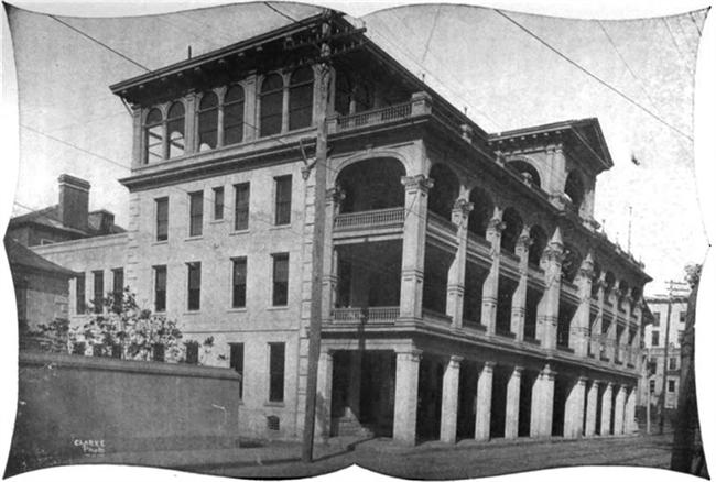 |
| A New Guide to Modern Charleston, 1912. http://books.google.com |
The Commercial Club stood on Meeting Street between the Charleston County Courthouse and Hibernian Hall. The building was a late-nineteenth century row of four attached tenements, remodeled as a residential/businessmen’s clubhouse ca. 1904. In 1918 the clubhouse was converted into the Timrod Inn (later known as Hotel Timrod). The hotel closed at the end of 1955, and in 1964 the building was demolished to clear a site for the O. T. Wallace County Office Building, today’s 101 Meeting Street.
|
| |
 TimrodBWPostcard_650x650.jpg) |
| Private collection |
Timrod Hotel, postcard view.
|
| |
 TimrodColorPostcard_650x650.jpg) |
| Private collection |
View of Timrod Hotel, facing south along Meeting Street.
|
| |
|